|
|
Post by deuce on Feb 14, 2018 14:48:11 GMT -5
My map of the Seven Empires during Kull's era. I drafted it in conjunction with the presentation I was invited to give at Howard Days 2007 in Cross Plains. In general, REH scholars from Patrice Louinet to Jeffrey Shanks to Chris Gruber agree that it is the most true-to-Howard/accurate map of its kind. Some latitude and longitude bearings are provided at the map's margins. 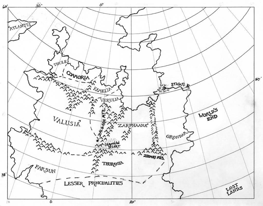 |
|
Deleted
Deleted Member
Posts: 0
|
Post by Deleted on Feb 14, 2018 15:00:11 GMT -5
Thanks for the excellent map, Deuce.
Will the map in the Kull Modiphius book be based on this one?
|
|
|
|
Post by zarono on Feb 14, 2018 15:44:28 GMT -5
Good stuff!
|
|
|
|
Post by elegos7 on Feb 14, 2018 21:21:59 GMT -5
Thanks for putting your excellent map on this forum as well, Deuce.
|
|
|
|
Post by deuce on Feb 15, 2018 1:44:04 GMT -5
Thanks for the excellent map, Deuce. Will the map in the Kull Modiphius book be based on this one? Glad you liked it, Hun. Regarding Modiphius, I'll just say that the odds are pretty good.  |
|
|
|
Post by ragnar on Feb 15, 2018 5:39:13 GMT -5
There's a Modiphius project around Kull? Colour me interested!
|
|
|
|
Post by Von K on Feb 15, 2018 19:34:40 GMT -5
Great map Deuce. On the old forum we could have asked Cromsblood if he'd add some colour.
|
|
|
|
Post by lordyam on Feb 23, 2018 21:26:12 GMT -5
whatever happened to him?
|
|
|
|
Post by deuce on Feb 24, 2018 3:31:39 GMT -5
|
|
|
|
Post by bazinga on Aug 3, 2018 7:28:07 GMT -5
Excellent map, Deuce! I'm currently researching the geography of the Thurian Age and this is really inspiring. In my googling, I'm been very disappointed in the maps I've found, but this one is amazing.
I really, REALLY love the way you've joined up the Stagus River with the Styx-to-be to the south. It's really cool having a conception of the Stagus that literally cleaves the world in two!
For me, there are a number of conflicting accounts which make mapping the Thurian age difficult.
Farsun: while "Riders Beyond the Sunrise" puts Farsun west of Valusia, "The Hyborian Age" states that Valusia is the country furthest west on the Thurian continent. Perhaps if Valusia here referred to the "City of Wonders" just as Rome referred to both the city and the empire, then Farsun could still be west of Valusia while Valusia envelopes it and remains the most western nation. The other explanation is that Farsun is an island nation, but I don't think this fits with the way it is presented.
Grondar: while "Riders Beyond the Sunrise" puts Grondar beyond Zarfhaana, "Swords of the Purple" kingdom mentions that the Grondarians were planning a huge raid into Valusia which Kull put to rest, but that seems less feasible after "Riders Beyond the Sunrise" puts Zarfhaana, Thurania and a sea between the two countries. Perhaps the Grondarians planned to push through one of these other realms or cross the sea. Or, the explanation I prefer, perhaps the Grondarians already had pushed through the neighbouring nations on a massive conquest, and it was Kull's forces which drove them back into their wild grasslands.
Another important thing to note is that "Kings of the Night" states that "the sea waves have rolled above the spires of Valusia for untold centuries!" This puts the Valusia at least a little out into the Atlantic Ocean, rather than superimposed over Europe. This also helps to explain how it seems to be so much easier to travel between Atlantis and the Pictish Isles than it is in our world to travel between Europe and America. However, I don't think Howard intended Valusia to be too far west of modern Europe, just enoug that most of it is now below the waves. Of course, this could just be artistic licence and he doesn't really mean it.
It is possible that Howard could have forgotten, made mistakes or changed his mind, but if solutions and explanations can be found that consolidate these contradictions, I would say those would be the better way of handling them.
What are your thoughts on Farsun and the quelled Grondarian invasion, and the westerliness of Valusia?
|
|
|
|
Post by deuce on Aug 5, 2018 14:42:32 GMT -5
Pretty short on time at the moment. Below you'll find my original post from the Old Forum. It was in response (researched and typed in about 4hrs) to a mod asking me why I said Tim Kirk's (albeit beautiful) map was inaccurate. I still stand by 95% of my reasoning.
Kaa-u (Pictish Isles): also called the Sunset Isles. Tim chose to slap "Kaa-u" on the Pictish Isles. I can understand his reasoning, but for various reasons I vehenmently disagree. The Isles are also WAY too close to the Thurian mainland. The general opinion (and mine) is that the Pictish Isles are the tops of what will be the Rocky Mts/Cascades in the Hyborian Age (and ours). Moving east to Atlantis, we find, instead of a "small continent", a large island approx. the size of Great Britain or Madagascar. Atlantis is stated to be a navigational obstacle to the Picts and Lemurians. Therefore, I see Atlantis extending from the Azores, following the Mid-Atlantic Ridge almost to where Iceland would later rise. I envision Atlantis as being widest in the south, to accomodate the "savannah" and "jungle" of the Am-Ra tales (it also matches up with Plato). It then narrows in the middle and again widens out in the north. Sorta "spoon-shaped", you could say, but more angular. The coordinates would be 35 N., 22-34 W. extending up to about 67N., 15-25W.
Farsun: a major key and anchor for the whole map. It would appear that the Picts were settled in the mountains of the northern Farsunian/Valusian frontier. According to "The Hyborian Age", that's where we find them at the start of the HA. According to "Worms of the Earth", that's where we find the Picts (the Basques) from Neolithic times to the present day. Basically, Farsun=Zingara=Iberian Peninsula. I have Farsun sticking out to 12 degrees W. to accommodate the extra land up north while still being "westernmost".
Commoria and Thule: Commoria and Thule aren't even mentioned in the Kull tales. Since "Thule" was originally applied to what geographers thought was the northernmost land, I'm placing it in the vicinity of the most northerly British Isles, about 60N., 8W. Commoria I see tucked into the southeast flank of Thule with no common border (in the time of Kull) touching on Valusia. Ever noticed the similarity between "Commoria" and "Cimmeria"? I think this is the area conquered by the northern Atlanteans.
Valusia: I place its western (coastal) boundary at about 6 degrees W., tucked in between the Farsunian and Thulean peninsulas, extending from 43-54 degrees N. Valusia (aka, "the City of Wonders"), the capital of the empire of Valusia, is positioned about where the Italian city of Bergamo is now situated. The Zalgara Mts. run north-south roughly along the 15 degrees E. meridian.
Kamelia and Verulia: I envision Kamelia (a kingdom that was also never mentioned in the Kull tales) occupying (roughly) a region including Holland, s. Denmark and n. Germany. It shares the northern Valusian border with Thule in Kull's day. I see Verulia situated s-e of Kamelia in the region roughly corresponding with Germany south of Berlin,plus Switzerland and w. Austria. This is because Dalgar, in "Swords of the Purple Kingdom", thought he could reach the Verulian border from the Valusian capitol IN ONE NIGHT!
Zarfhaana: I see this ancient kingdom encompassing Poland (s. of Warsaw), Slovakia, Hungary and Serbia (very roughly). There's a gulf n. of Warsaw "swarming with pirates and sea-rovers". The Camoonian Desert is now covered by the nations of Croatia and Bosnia. The Zhemri Mts.,"in the southeast", which "I" take to mean "the southeast of the Seven Empires", are basically the Balkans today. The "Zarfhaana'an Mts.", where lies Talunia, run roughly north-south on the 25 degrees E. meridian.
Grondar: lies betwixt the 25 E. and 35 E. meridians. Its n. border is where the Stagus empties into the "Zarfhaana'an Gulf". It's s. border lies somewhere about the 42-43 N. parallel.
Stagus R. and the World's End: I believe REH intended the Stagus to become the Styx after the Cataclysm. Instead of running due north, the Cataclysm turned the course of the Stagus due west at the 35 N. parallel. I've had the Stagus "meander" 5 degrees east to give Grondar a little more room. The World's End? It stretches east for a LOOONNG ways.
Thurania: covers an area stretching roughly from Sardinia to Istanbul, south to Crete and west to Tunis. It shares a western border with Farsun, its ancient enemy. VERULIA is never described as being south of Valusia.
The "lesser principalities": stretch in an arc 100-200 miles deep, starting from Grondar's s-e border all the way to Farsun.
The Lost Lands: Good call on Tim's part, IMO. Why are they called "the LOST Lands"? I think there's a very interesting answer for that, but I shan't go into it now. I think they occupy a major portion of what we now call the Middle East.
|
|
|
|
Post by bazinga on Aug 6, 2018 10:19:15 GMT -5
Thanks for sharing, Deuce!
I think the very "square" look of many of the nations matches how Howard would have drawn them, as we see in his Hyborian Age maps.
I also like the way most of Valusia will be drowned, matching the description in "Kings of the Night."
I really think my only nitpick is that the western part of Farsun ought to extend further north to allow the description given in "Riders Beyond the Sunrise," that riding west will bring them to Farsun, to hold true. But I also picture Farsun as being somewhat of an Iberian stand-in as you do.
I also still wonder how the Grondarians planned on launching a raid into Valusia when they have so many countries separating them. Perhaps by boat? This was, after all, a seafaring age.
|
|


