|
|
Post by deuce on Oct 30, 2016 9:43:07 GMT -5
I've been meaning to start this thread for awhile... Robert E. Howard gave us more info on Aquilonia, by far, than any other nation of the Hyborian Age. Aquilonia is the setting of the very first Conan yarn, The Phoenix on the Sword. It is also the setting of The Scarlet Citadel, The Hour of the Dragon, Beyond the Black River and Wolves Beyond the Border. In addition, there's a lot of geo-political data on Aquilonia in other Conan tales, as well as "The Hyborian Age" and various notes and drafts by REH. With this wealth of data, it should be possible to make much better maps than what we've seen up to now. I hope to hear from whomever happens to be interested in this project.  This is the 1936 REH map, the final and most detailed map Howard ever made of Aquilonia and the Hyborian Age in general. .jpeg) |
|
|
|
Post by lordyam on Nov 2, 2016 14:01:17 GMT -5
So Aquilonia would be where France is, Nemeida would be Germany.....Koth would cover a little bit of Italy and parts of Anatolia. Zinger would be spain....Ireland would be pictland....poor argos would be under water.
|
|
|
|
Post by deuce on Feb 12, 2017 14:09:14 GMT -5
From the untitled notes REH prepared before starting "Wolves Beyond the Border"... The Westermarck: located between the Bossonian marches and the Pictish wilderness. Provinces: Thandara, Conawaga, Oriskonie, Schohira. Political situation: Oriskonie, Conawaga, and Schohira were ruled by royal patent. Each was under the jurisdiction of a baron of the western marches, which lie just east of the Bossonian marches. These barons were accountable only to the king of Aquilonia. Theoretically they owned the land, and received a certain percentage of the gain. In return they supplied troops to protect the frontier against the Picts, built fortresses and towns, and appointed judges and other officials. Actually their power was not nearly so absolute as it seemed. There was a sort of supreme court located in the largest town of Conawaga, Scanaga, presided over by a judge appointed directly by the king of Aquilonia, and it was a defendent’s privilege, under certain circumstances, to appeal to this court.
Thandara was the southernmost province, Oriskonie the northernmost, and the most thinly settled. Conawaga lay south of Oriskonie, and south of Conawaga lay lay Schohira, the smallest of the provinces. Conawaga was the largest, richest and most thickly settled, and the only one in which landed patricians had settled to any extent. Thandara was the most purely pioneer province. Originally it had only been a fortress by that name, on Warhorse River, built by direct order of the king of Aquilonia, and commanded by royal troops. After the conquest of the province of Conajohara by the Picts, the settlers from that province moved southward and settled the country in the vicinity of the fortress. They held their land by force of arms, and neither received nor needed any patent.As we can see from the REH map above, the Westermarck was beyond the Bossonian Marches. The pastiche map below, while not bad in a few ways, doesn't show the Marches extending from the Zingaran border to the Border Kingdom, as is the case. Another question that needs looked at is whether the rest (or parts) of the Westermarck -- which obviously survived the fall of Tuscelan and Conajohara -- lay west or east of the Thunder River. This map falls squarely in the "east" camp. We will return to this map, which shows a little bit of erudition (Attalus) and a whole lot of ignorance/misinterpretation. Click link below for full-sized map:conan.wikia.com/wiki/Aquilonia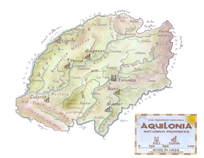 |
|
|
|
Post by deuce on Mar 7, 2017 10:27:46 GMT -5
Thought I'd bump this thread with some artwork from our old friend, Pictish Scout: pictishscout.deviantart.com/He's done a better job than most in accurately depicting -- ie, according to REH -- the various borderland ethnic groups/frontiersmen of Aquilonia. I've been doing a lot of research on Aquilonian geography and whatnot. That will be showing up on this thread in good time. 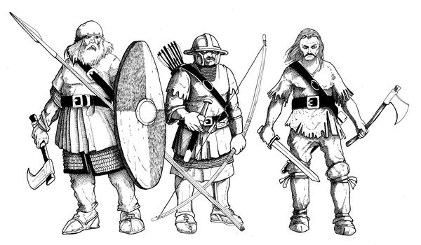 |
|
|
|
Post by deuce on Mar 24, 2017 17:35:14 GMT -5
From the untitled notes REH prepared before starting "Wolves Beyond the Border"... The Westermarck: located between the Bossonian marches and the Pictish wilderness. Provinces: Thandara, Conawaga, Oriskonie, Schohira. Political situation: Oriskonie, Conawaga, and Schohira were ruled by royal patent. Each was under the jurisdiction of a baron of the western marches, which lie just east of the Bossonian marches. These barons were accountable only to the king of Aquilonia. Theoretically they owned the land, and received a certain percentage of the gain. In return they supplied troops to protect the frontier against the Picts, built fortresses and towns, and appointed judges and other officials. Actually their power was not nearly so absolute as it seemed. There was a sort of supreme court located in the largest town of Conawaga, Scanaga, presided over by a judge appointed directly by the king of Aquilonia, and it was a defendent’s privilege, under certain circumstances, to appeal to this court.
Thandara was the southernmost province, Oriskonie the northernmost, and the most thinly settled. Conawaga lay south of Oriskonie, and south of Conawaga lay lay Schohira, the smallest of the provinces. Conawaga was the largest, richest and most thickly settled, and the only one in which landed patricians had settled to any extent. Thandara was the most purely pioneer province. Originally it had only been a fortress by that name, on Warhorse River, built by direct order of the king of Aquilonia, and commanded by royal troops. After the conquest of the province of Conajohara by the Picts, the settlers from that province moved southward and settled the country in the vicinity of the fortress. They held their land by force of arms, and neither received nor needed any patent.As we can see from the REH map above, the Westermarck was beyond the Bossonian Marches. The pastiche map below, while not bad in a few ways, doesn't show the Marches extending from the Zingaran border to the Border Kingdom, as is the case. Another question that needs looked at is whether the rest (or parts) of the Westermarck -- which obviously survived the fall of Tuscelan and Conajohara -- lay west or east of the Thunder River. This map falls squarely in the "east" camp. We will return to this map, which shows a little bit of erudition (Attalus) and a whole lot of ignorance/misinterpretation. Click link below for full-sized map:conan.wikia.com/wiki/AquiloniaFor whatever reason, I can't link to a full-sized version of the map above. However, there is one in this pdf: dnd.rushland.eu/Conan/Aidesconan/Conan_1st_Edition-WEB-Aquilonia.pdfLike the map itself, the pdf text is full of pastichery and other silliness. There are a few bits of actual accurate data in there, though |
|


